

Becky Wheeler, Farm Advisor, UCCE Glenn, Colusa and Tehama Counties
Recent advances in imaging technologies combined with highly accurate GPS tracking can provide growers with detailed and precise information about their orchards. While there are no current UC replicated studies on the use of the technology in prunes, several growers report using it to help estimate crop load when making thinning decisions. Dropcopter, a local company based out of Northern California, utilizes the Green Atlas Cartographer unit to rapidly scan orchards providing growers with data on bloom, crop load, and other tree characteristics to help make management decisions. Dropcopter has been used on over 10,000 acres across California and their footprint continues to expand.
Prune growers are faced with difficult thinning decisions annually. An accurate understanding of the crop load of the trees is critical in choosing whether and how much to thin to maximize the potential quality of the fruit at harvest. However, orchards can be highly variable based on soil types, proximity to water sources like canals or neighboring rice fields, and the history of the field. Tools like Dropcopter’s crop scanning services can help growers understand variability in the field as well as gain a better understanding of the total yield expected. Additionally, processors can utilize the technology later in the summer to get a more accurate estimate of the crop that will be coming into the dryer, making labor and logistical planning easier.
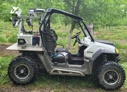
Figure 1. Dropcopter’s Green Atlas Cartographer in a prune orchard.
The Green Atlas Cartographer is essentially a UTV with LiDAR (light detection and ranging) imaging and GPS hardware attached to it (Figure 1). The Cartographer drives quickly up and down every row of an orchard, collecting thousands of high-resolution images. The Cartographer can cover approximately 250 acres in 8 hours, and the machine can be used 24 hours a day since the imaging equipment utilizes powerful flash lighting. Dropcopter personnel then ground truth the data by counting the fruit on 6 trees to put actual numbers to the comparative data. Imaging data is then processed by Dropcopter, combined with the ground-truthed field numbers, and is available to the grower within 48 hours. The data includes the number of fruit per tree, fruit size, color index, canopy size and density, and leaf area. Growers can request the data in a variety of formats, including on a tablet, on a USB thumb drive, or printed. Maps can be very granular with nearly tree-by-tree data (Figure 2) or can be blocked into zones. The data can be translated into actionable management decisions in several ways. For example, a zone map of crop load can be loaded onto a tablet and on display in the cab for shaker operators. A GPS marker indicates to the operator which zone they are in and a simple color-coding system indicates which trees to thin hard, which to only lightly thin, and which trees not to thin at all.
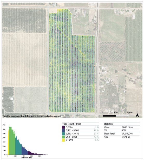
Figure 2. Example of data returned from crop sensing in a prune orchard. Dot colors on the field map indicate the number of fruit per tree, and total field statistics are summarized beneath the image.
Prune growers can currently get the most bang for their buck by using Dropcopter’s crop sensing services to inform thinning decisions. As more technologies like variable rate fertilizer applications become available and accessible, the data provided has the potential to inform increasingly precise farming decisions, minimizing waste and maximizing efficiency. More accurate industry-wide crop estimates can also improve efficiency for handlers, and for processor marketing strategies both domestically and internationally. The future of this technology is exciting and has great potential for keeping prune growers as profitable as possible in a competitive global market.
To learn more about Dropcopter or to schedule crop sensing services, please visit www.dropcopter.com or contact Matt Koball, Dropcopter Founder and CEO, at mattk@dropcopter.com.
*Please note that this article does not serve as an endorsement of products or services described, but rather an informational article on a new technology available to growers
Leave a Reply